Sample report: generated for an ordinary public residential lot; the address and Lot/DP are shown as sample values.
Granny Flat Assessment Report
- Address
- Sample address
- Lot/DP
- Lot (sample)
- Council
- City of Parramatta
- Report number
- HAD-261029-4YK7 · Version 2
- Generated
- 2026-10-29
Summary
Preliminarily feasible · CDC with conditions
2 designs fit with conditions; recommended: COOGEE (30 m² · 1 bed)
Key reasons
- C7 Rear setback: Rear setback 3.49m is less than the required 6.60m; fails only because of the height addition — met if the design is ≤ 3.8 m tall
- E2 Distance to the house: 0.76m from the house, under 1.80m — fire-rated wall needed
Not checked: A2 Restrictions on title (88B) · B7 Other CDC exclusions · B8 Mine subsidence · B9 10.7 complying development statement · C10 Living-room window setback · E6 Easements · E7 Sewer main · E8 Manholes and connection points · E9 Stormwater · E10 Reticulated sewer · E11 Delivery and crane access
17 pending review · 11 estimated
This is a preliminary assessment from public data — upload documents for a full assessment
Next steps
- Upload the 10.7 certificate, DP, title search and sewer service diagram for a full assessment
- Resolve the 'caution' and unchecked items (e.g. survey, BAL assessment, flood certificate), then engage a registered certifier for the CDC
Recommended design:COOGEE
Lot profile
- Area
- 786.0 m²estimated
- Frontage
- 2.0 m
- Zoning
- R2
- Floor space ratio
- 0.5 : 1
- Height limit
- 9.0 m
- Minimum lot size
- 550 m²
- Council
- City of Parramatta
- LEP
- Parramatta LEP 2023
- Sewer authority
- Sydney Water
Site health
- Flood· Unknown
- Bush fire· Pass
- Heritage· Pass
- Landslide· None found
- Acid sulfate soils· Class 5
Check details
Every check: status, explanation, basis, data source and small print. Design checks use the recommended design at its current position.
Service scope
- S1 StatePassThe lot is in NSWBasis:服务范围 · Data source:NSW cadastre
- S2 Council reference dataPassCouncil reference data availableBasis:服务范围 · Data source:NSW official layers · NSW Administrative Boundaries · LocalGovernmentArea · queried 2026-10-28
- S3 Number of lotsPassSingle lotBasis:服务范围 · Data source:NSW cadastre
- S4 Title type
Site constraints
Lot, statutory setback line, main house, easements, sewer and manholes, with the buildable / avoid / no-build zones for the recommended design's height.
Recommended designs · COOGEE
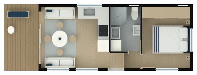
Checks for this design
- C1 Floor areaPasspending reviewestimatedInterior area 30.0㎡ ≤ 60.0㎡
- C2 Total floor areaPass
Top-down render
3D views and realistic renders are not available yet. This page shows the coordinate-composed top-down render (clean version); constraints and distances are on the design layouts (annotated).
DA reference
DA reference (not part of the assessment)
- D1 Lot size under a DA
- Lot ≥ 450 m²: the council cannot refuse on lot size (Housing SEPP s53)
- D2 Floor space ratio
- About 0.39:1 (LEP maximum 0.5:1)estimatedreference
- D3 Council DCP requirements (DA only)
- Landscaped area ≥ 30%Site coverage limit: reference value being checkedPrivate open space ≥ 24 m²The DCP may ask for 1 extra parking space(s); the council cannot refuse on parking if parking is unchanged (Housing SEPP s53)Separate water / power meters may be requiredLEP area cap: 60 m² (state rule); the council may allow morereferencepending review
- D4 Estimated contributions
- About AUD 10k–20k (s7.11); the council's contributions plan appliesreference
- D5 Estimated approval time
- CDC: a few weeks; DA: about 3–6 monthsreference
Next steps
Recommendations
- Upload the 10.7 certificate, DP, title search and sewer service diagram for a full assessment
- Resolve the 'caution' and unchecked items (e.g. survey, BAL assessment, flood certificate), then engage a registered certifier for the CDC
Documents still needed
10.7 planning certificate · Deposited plan (DP) · Title search · 88B instrument · Sydney Water service location print · Survey plan · Flood certificate · BAL report
Consultants you may need
Registered certifier (CDC) · Town planner (DA) · Registered surveyor (boundary and levels) · BAL consultant (bushfire prone land) · Solicitor (title restrictions)
Typical process
Complete the documents → confirm the design and position → certifier review and CDC (or DA lodged with council) → pre-construction checks and Sydney Water approval
Data sources and notes
| Data | Source | Queried |
|---|---|---|
| Floor space ratio | NSW official layers · NSW Planning Portal · Floor Space Ratio Map | 2026-10-29 |
| Zoning | NSW official layers · NSW Planning Portal · Land Zoning Map | 2026-10-29 |
| Flood | NSW official layers · NSW Planning Portal · Flood Planning Map | 2026-10-29 |
| Council | NSW official layers · NSW Administrative Boundaries · LocalGovernmentArea | 2026-10-29 |
| Bush fire | NSW official layers · NSW Planning Portal · Bushfire Prone Land | 2026-10-29 |
| Heritage | NSW official layers · NSW Planning Portal · EPI Heritage; NSW Planning Portal · State Heritage Register Curtilage | 2026-10-29 |
| Area | System estimate · Cadastral boundary geometry | 2026-10-29 |
| Landslide | NSW official layers · NSW Planning Portal · Landslide Risk Land | 2026-10-29 |
| Height limit | NSW official layers · NSW Planning Portal · Height of Buildings Map | 2026-10-29 |
| Minimum lot size | NSW official layers · NSW Planning Portal · Minimum Lot Size | 2026-10-29 |
| Acid sulfate soils | NSW official layers · NSW Planning Portal · Acid Sulfate Soils | 2026-10-29 |
Disclaimer
- This report is an assessment based on public data and documents you provided; it is not planning, legal or engineering advice.
- A CDC must be issued by a registered certifier or council; a DA is determined by council.
- Lot boundaries and service locations carry errors; applications must rely on a registered surveyor's survey.
- Documents were read by AI and confirmed by the user; the original documents prevail.
- Renders are illustrative and not a basis for construction.
- Data queried: 2026-10-29; report number: HAD-261029-4YK7.